
Community Assessment - Kim Buttery
Students should be able to
- describe why community assessment is important for analyzing community health status
- describe the sources of data available for such analysis
- describe how to gather and present the data that affect community public health policy & funding
- describe data sets available to measure health status at the national, state and local level
- how to link the health data to economic status
- GIS Objectives:
After this session students should understand the added value of epidemiologic analysis using GIS and geocoding software. They should understand the expanding use of census tracts for analyses. They should be able to explain where they can obtain data. They should understand the elements of enhanced data quality provided by GIS-related tools. They should be able to describe the major software available, including common use within the public health community.
Key Words
Community, jurisdiction, health status, health measurement, planning, goals, birth rate, infant death rate, fertility measures, community surveys, behavioral risk factors, mental health, Marc Lalonde, Kerr White.
GIS Key Words: Maps, streets, block groups, census tracts, zip codes, geocoding, spatial analyses, Census Bureau.
Concept
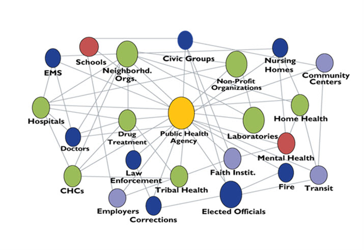
Improving health outcome depends on knowledge of current health status rather than just responding to medical crises. One problem you need to grapple with is the definition of a community which may be a group of individuals located in a geographic area such as a city county or state. However a community may also be a group of individuals defined by specific attributes such as having HIV, or tuberculosis or being affected by specific environmental toxin. Over the last 10 years there has been interest from the world health organization as the "healthy cities" program was developed with branches in the United States by the National Civic League . Click on the Community Services tab, then the strategic vision link. It has received a lot of interest and spun off into the healthy communities program which in the United States has had major interest from the Robert Wood Johnson Foundation and the University of Washington with the annual updates to the healthy communities data sets, which measure comparative health among the various states and counties, See the 2015 rankings, Compare your community with others around the nation and review this JAMA Viewpoint. One cannot discuss a healthy community without linking health concerns to community planning & development. When thinking about setting community goals look at the HP2020 midterm review (PDF) , think back the the discussion of Goals. Hospitals have been required, as part of the accreditation, to develop a community assessments as part of their service. However few have done this and be part of any duty wide programme, but done this purely in-house. Also look at the National Neighborhood Indicators sponsored by the Urban Inst., click on the first four tabs and scan the purpose and activities in developing healthy neighborhoods. Stewart Butler recommends in this article more proactive position be taken by hospitals to become part of the community assessment. Read the article. Also look at the following presentation of linkages among partners and communities to think about who to include when you plan a community assessment.
GIS: Epidemiology concerns the distribution of disease with a space and time continuum. Geographic information systems (GIS) allow a visual display of data distribution, as well as affiliated attributes, at varying levels of geographic granularity. Additionally, GIS is being used to enhance data quality management and improve our understanding of socioeconomic factors related to public health surveillance. The use and need for GIS tools and spatial analyses of public health data is increasing, as is evidenced by the growing body of GIS-related literature.
Readings:
Essay # 3, & scan essay #6.
Schneider 4/5th Edns: scan Chapter 8.
A view from the BMJ on building a healthy society.
Kaiser Family Foundation: State Health Facts which expands the RWJ community health status data sets. Click on the various options to examine the data available. The HP2020 is a basic document for an assessment.
Read this recent (April 2015) Institute of Medicine update on Community Assessment and the Affordable care act Pages2-12), Hospitals have had a requirement from their accreditation agency.
GIS Readings: The National Association of State and Territorial AIDS Directors (NASTAD) Prevention Bulletin. June 2007. Read the first four topics below.
Targeting Populations Using Geo-Mapping and Social Network Strategies
- How do we target populations? (Using HIV as a model)
- Geo-Mapping the Rats of New York
- Virginia’s Experience with Geo-Mapping (mouse down to the second section of the report, Geo-Mapping.)
- Welcome to
ESRI GIS Page as well as the HHS page, you might want to look at the community analyst video. It is a little long but pertinent. You should probably look at all the rest of the topic and come back to this if you have time, then look at the ESRI Spring 2015 State Local News and review the articles on pages 3 and 10 - September 3, 2013 from Richmond Times Click on the Link to the map, click on 'add labels' and focus down on Richmond or your home area until you see the dots that represent people.
GIS Optional readings:
Monmonier, M. 1991. How to Lie With Maps. The University of Chicago Press.
Monmonier, M. 1993. Mapping It Out. The University of Chicago Press * Monmonier, M. 1997. John Snow's legacy. Cartographies of Danger: Mapping Hazards in America. The University of Chicago Press. Ricketts, T.C. and L.A. Savitt, W.M. Gesler, et al. 1997. Using Geographic Methods to Understand Health Issues. (AHCPR Pub. No. 97-N013). Rockville, MD: Agency for Health Care Policy and Research (NTIS No. PB97-137707). Koch. T. 2005. Cartographies of Disease: Maps, Mapping, and Medicine. ESRI Press. Wade T. and Sommer S. ed. 2006. A to Z GIS: An Illustrated dictionary of geographic information systems. ESRI Press. Cromley & McLafferty. 2002. GIS and Public Health. Guilford Press.
GIS Additional Readings:
- Bozzetta SA et al.(1998) The care of HIV infected adults in the United States. New England Journal of Medicine 339(28): 1897-1904
- Principles of Community Engagement.
- A new Perspective on the Health of Canadians, Marc Lalonde. 1974
- Community Assessment using maps
Articles
- Geography gaining power as a tool for shaping health and social policy. 1997. Advances: The Quarterly Newsletter of the Robert Johnson Wood Foundation, Issue 3.
- Rushton, G. et al. July 1995. A geographic information analysis of urban infant mortality rates. Geo Info Systems. 52-56.
- Tempalski, B. and S. McLafferty. June 1997. Low birth weights in New York City: using GIS to predict communities at risk. Geo Info Systems 7, 6: 34-37
 click on this icon
Go to Lecture